Numerous extinct and dormant volcanoes are dotted across the New Zealand landscape. There are even a handful of active ones just to keep things interesting. The larger volcanoes are spectacular and provide photo opportunities and sporting activities to both visitor and locals alike.
The largest concentration of dormant volcanoes is found across Auckland. The city sits on a volcanic field with an estimated 53 cones and craters dotted amongst the urban sprawl. The sides of the cones are grass covered as Maori disapprove of housing on their slopes. For this reason, the cones stick out like green pimples on Auckland’s face! Dormant means they could erupt again in the future. In fact just recently, new measures were taken to monitor underground movements. If the city’s stomach gets indigestion, it’s time to run for the hills. Authorities tell Aucklanders they will have around 30 minutes to flee an eruption once a rumble has been detected!!!!
 Cluster of Auckland’s Volcanic Cones (aucklandnz.com)
RANGITOTO
As far back as 1890, attractive Rangitoto Island was declared a recreation reserve. The little volcano is believed to have been active off and on for 1000 years. It last blew its top 550 years ago making it the area’s youngest volcano. After European settlement, basalt was mined on the island to help in the construction of Auckland’s buildings and roads. Iconic Rangitoto (Maori for “Bloody Sky”) is located in the centre of Waitemata Harbour and can be seen from most parts of the inner city and is the most recognised natural landmark in Auckland. Around 30 holiday huts cluster at the water’s edge but there are no permanent residents on the island. I’ve not been there myself, but have been told it is an interesting place to experience, mainly due to the ferns and orchids that flourish in the old lava fields. A ship cemetery is also fascinating with the wrecks of a number of vessels slowly decaying along the northern shore.
 Rangitoto (newzealand.com)
HARBOUR CONE
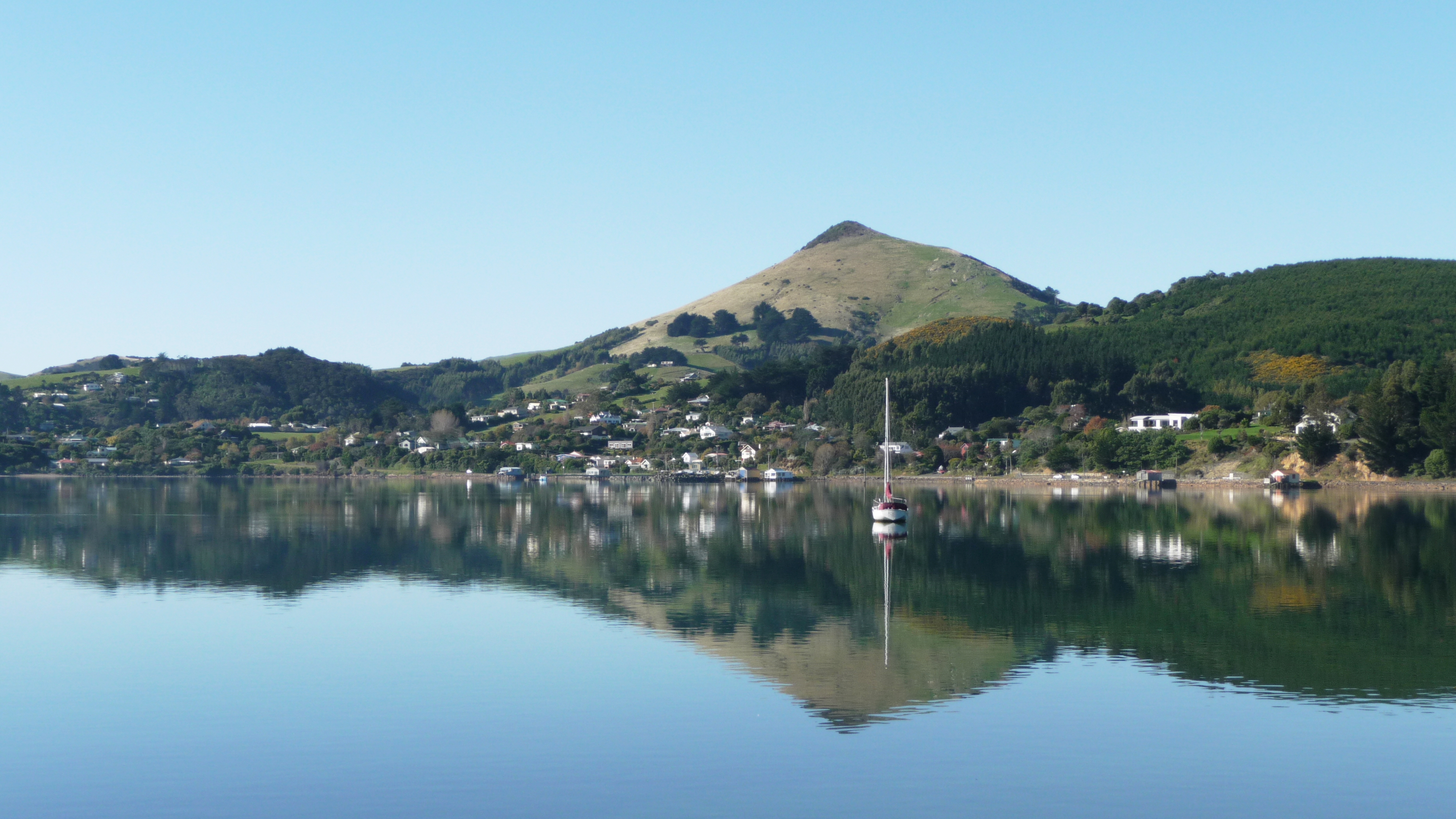
Another iconic seaside volcano is on the Otago Peninsula and like Rangitoto, it can be seen from most parts of the harbour. Unimaginatively named Harbour Cone, the graceful curve of the cone rises above Portobello, one of the main settlements on Otago Peninsula, just a 10 minute drive from the centre of Dunedin City.
 Harbour Cone (Ceidrik Heward)
A 5 hour tramp around the cone has become popular with energetic tourists since a track was established a decade ago. Larnach Castle, one of New Zealand’s top tourist attractions, is just a stone’s throw from Harbour Cone and the view from the grounds of the castle across to the volcano and the upper harbour, is to my mind, one of the most beautiful vistas in New Zealand.
 Harbour Cone from Larnach Castle (Ceidrik Heward)
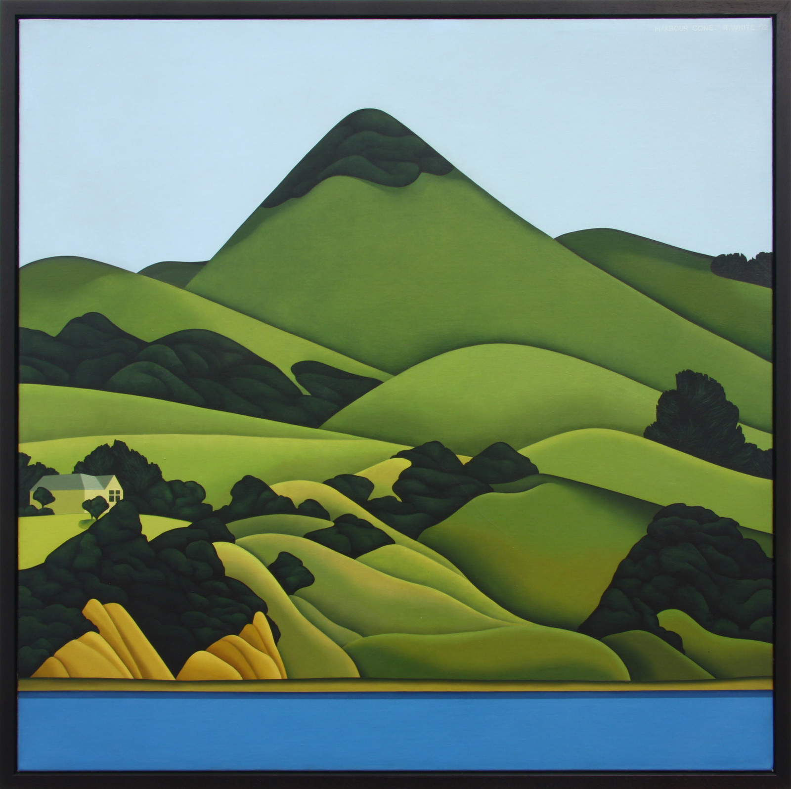
Renowned New Zealand artist, Robin White moved to Portobello in the early 1970s. The artist was so captivated by Harbour Cone that it has featured in 16 of her paintings. These paintings have become iconic New Zealand art pieces and when auctioned, they have fetched over $65.000. Some are hung in prestigious galleries in New Zealand and overseas.
 Robin White: Harbour Cone
EGMONT/TARANAKI
The 2,518 metres (8,261 ft) Mt. Egmont was given its name by James Cook on the 11th January 1770. The Maoris call it “Taranaki”. This eye catching mountain is recognized for having one of the most symmetrical volcanic cones in the world. The last major eruption occurred around 1655. The most recent volcanic activity took place in the 1860s with the collapse of a lava dome down the side of the mountain. Recent research has shown that minor eruptions have occurred roughly every 90 years, with major eruptions every 500 years. It’s time for another one. Yikkes!!

In 1881 the area surrounding the mountain was designated a forest reserve and in 1900 this area became Egmont National Park, the second oldest national park in New Zealand.
Mt. Egmont is located a short distance from New Plymouth. Being so close to the city, various sporting clubs have established activities on the mountain. There are tramping, walking and hiking trails. There is even a small ski field.
I’ve been told that on a clear day, Mt. Egmont can be seen from the top of the South Island. Every time I’ve been in the district I’ve been drawn to gaze at this stunning volcano. Surrounded by lush green fields, the snow capped top is all the more dramatic to behold. It really seems a little odd to see it plonked in the centre of gently rolling countryside as opposed to the usual volcanic landscape where most other volcanoes tend to be situated.
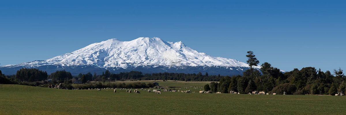
RUAPEHU
This is an active volcano! It last erupted in 2007 when two lahars rolled down the mountain accompanied by a 7 minute long earthquake. This is the country’s largest volcano and claims the tallest point of the North Island. Despite being active, its slopes are home to the North Island’s two most popular ski fields. Located almost equidistant between Auckland and Wellington, it attracts skiers from both cities. Whakapapa on the northern side attracts skiers from Auckland and Hamilton while Turoa on the southern side attracts skiers from Palmerston North and Wellington.
 Mt. Ruapehu (newzealand.com)
Ruapehu is part of the highly active Taupo Volcanic Zone. The bubbling, gurgling mud found around Rotorua is part of this volcanic zone and along with Ruapehu, there are two other active volcanoes that are carefully monitored around the clock.
I’ve driven past Mt. Ruapehu on numerous occasions but it has never had the same impact on me that the other volcanoes I’ve spoken about in this blog have had. It lacks the obvious look of a volcano. This is because it’s made up of three peaks so is really a trio of cones bonded together, so it doesn’t really look like a volcano. It’s only when you see a plume of steam rising from its bulk, that you know it’s no ordinary mountain.
TONGARIRO
Dormant since 1897, Mt. Tongariro sprung to life again on 6 August 2012 when it fired blocks as large as 1 metre (3 ft) across 2km of the surrounding land. An ash cloud 6.1km (3.8 miles) high, 25km (16 miles) long and 15km (9.3miles) wide travelled 250km (160 miles) in four hours. In other words, this was a seriously impressive eruption!
 Mt. Tongariro (newzealand.com)
Mt. Tongariro is located in the national park of the same name and is a World Heritage site. It’s New Zealand’s first national park and actually one of the first national parks established anywhere in the world. This volcano appeared in the Lord of the Rings trilogy and is now a popular destination for trampers who want to experience the Tongariro Alpine Crossing. I reckon the main attraction of the walk over this track is not to see the little crater lake which is billed as an attraction, but the danger of an eruption at any moment. This appeals to the ‘boy racer’ mentality of thrill seekers and I’m sure the Tongariro Alpine Crossing wouldn’t be anywhere near as popular if it was on a dormant volcano. The smell of sulphur in the air and the wisps of steam rising from various parts of the walk, with the looming alive cone of the volcano itself, are what makes this tourist venture so exciting.
 Tongariro Alpine Crossing (newzealand.com)
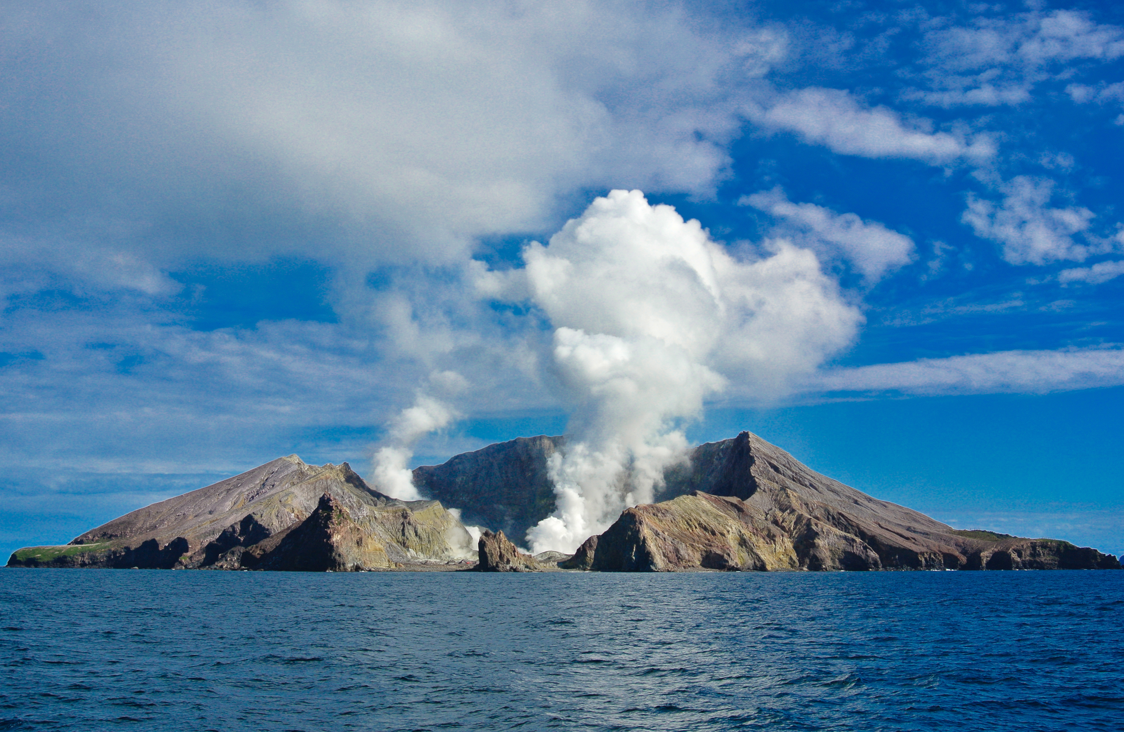
WHITE ISLAND
As the name suggests, this volcano has formed into an island and is New Zealand’s most active volcano. In fact, it’s been continuously erupting since first put on the map by James Cook in 1769.
The privately owned volcanic island is 48km (30miles) from the coast. It is 2km in diameter and of course is just the tip of a much larger mountain that is mostly submerged. From the 1880s, miners lived on the island to extract sulphur for gunpowder and fertiliser. However, disaster struck in September 1914 when an eruption killed the 10 workers living there. The only survivor was one of the five cats that lived there. Today, a few factory walls still stand and are one of the attractions for tourists who are allowed to visit by arrangement with the island’s owner.
 White Island (whakatane.com)
I’ve not been to White Island but I’ve seen the white steam rising from the ever active crater. It is a rather unique sight as from a distance the plumes appear to rise from the ocean itself. Visitors to the island talk about the hundreds of fumaroles that emit plumes of steam between the yellow sulphur chimneys and white oxidised crystals. Muddy pools bubble with gases escaping. It must be a bit like walking over a huge steam engine working feverishly underfoot. Visitors also comment on how hellish it must have been for the miners who lived there.
 White Island Ruins
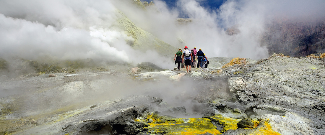 White Island dangerous Landscape
Geologically speaking, New Zealand is one of the planet’s youngest countries. When you travel around it and see how alive the countryside can be, it is easy to believe this fact. There is something exciting about being in a young country. Let’s hope it manages to behave. None of us want nature to throw a fit and cause any more damage to the beautiful country she has created for us to all enjoy.
Sadly, since posting this blog, a disastrous explosion on 9th December 2019 killed 21 tourists while they were exploring White Island. It remains closed to all visitors.
Ceidrik Heward
Ceidrik Heward is an Amazon TOP SELLING AUTHOR and has lived and worked in 7 countries working as a TV cameraman, director and film tutor. For the past 17 years he has focused on writing and has been published in magazines and newspapers in Europe, USA, Asia and the Middle East.
His interests include photography, psychology and metaphysics. He loves to read and always has at least 3 books on the go. He has written 22 manuals/books and has just completed his 4th short novel. Ceidrik believes sharing information and stories is the best way to stimulate the imagination and enrich our lives.


 Visit Today : 240
 Total Visit : 1074895
Speak Your Mind