New Zealand’s Southern Alps form one of the most mountainous landscapes in the temperate world. The highest peak, Mt. Cook, rises 3,724m (12,217ft) and is just one of the peaks that make up this 600km (372miles) chain of mountains. The Southern Alps has been a formidable barrier for travel across the South Island from the Pacific Ocean to the Tasman Sea. Today, there are three road passes and three tracks only for hikers.
HARPER PASS
Harper Pass (elevation 962 metres or 3,156 feet) was the first alpine pass between Canterbury and the West Coast. Maoris used it in their search for greenstone. The first European negotiated the pass in 1857 and the leader of the second party to follow him on the dangerous route later that year, Canterbury MP Leonard Harper, gave the pass its name. Harper Pass remained the only way over the Southern Alps for some years. When the West Coast gold rush started in 1864, it became heavily used with over 2000 miners trudging through dense forests and negotiating the track’s dangerous rivers with pack horses in the first few weeks of the gold discovery. Harper Pass is the lowest of the four Southern Alps passes and remained well used until October 1865, when gold finds began to dry up and it fell out of use. The gruelling 75km (47miles) Harper Pass Track was restored in the 1930s and takes 5 days to walk and is today part of New Zealand’s long distance tramping route which spans the entire country.
BROWNING PASS
European surveyors who crossed Browning Pass in 1865 drew lots to determine which of them the summit lake should be named after; Robert Browning was the winner. This pass leads from the Wilberforce River in Canterbury to the Arahura River on the West Coast. In 1865 a track was made so that sheep could be driven from Canterbury to Hokitika, which was thriving due to the gold rush. The sheep were then slaughtered to provide fresh meat for the miners. The pass was the location for brutal Maori inter-tribal killings and like Harper Pass, was also used by them to transport West Coast greenstone to the European settlers in Canterbury who paid good prices to buy it.
Most keen trampers will have either been, or plan to go, over Browning Pass at some time in their outdoor career because it is part of the classic Three Passes Route through the Main Divide from the Upper Waimakariri River to Westland and also includes Harman and Whitehorn passes (which do not fully traverse the Southern Alps). The scenery around Browning Pass is bleaker than that found in Harper Pass with tussock coated slopes and scree covered valleys. Snow tends to hang around all year long and of course, like all the Southern Alp passes, there is plenty of rain and rapidly changing weather conditions.
WHITCOMBE PASS
In early 1863, Thomas Cass, chief surveyor for Canterbury, enlisted Whitcombe and Lauper to seek a new route to the West Coast. John Henry Whitcombe was a provincial surveyor, originally from Devon, England, who had also worked in India. Jakob Lauper hailed from Switzerland, where he had worked as a mountain guide—an ideal background considering the precipitous country he was about to survey.
Starting their journey in the upper reaches of the Rakaia, John and Jakob struggled through brutally challenging terrain for three weeks, until they finally reached the Tasman Sea on the West Coast. It was there that Whitcombe tragically lost his life when the explorers attempted to cross the flood swollen Taramakau River. Their makeshift raft capsized and the men were swept out to sea. Jakob, the stronger swimmer made it to shore while John Whitcombe succumbed to the pounding waves.
The pair’s goal was to map an East – West route, suitable for constructing a road link between Christchurch and the West Coast. This Main Divide pass separates the gravel plains of the Rakaia from Westland’s lush temperate rainforests; a trek through such contrasting terrain is regarded as exhilarating by trampers who negotiate the dangerous route in summer and autumn.
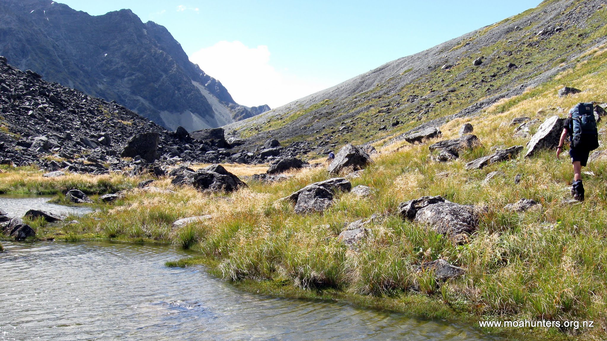
Whitcombe Pass (moahunters.org.nz)
ARTHUR’S PASS
The first European explorers preferred to cross the Southern Alps by the Harper Pass. By 1863, as an endless train of gold-seekers, packhorses, cattle and sheep reduced the bridle path to a boulder strewn mud slurry an alternative route became necessary. In February 1864 the surveyor Arthur Dobson and his brother Edward rode horses up the Waimakariri River in search of a new route west. On reaching the Bealey Valley, they followed this to its head, then crossing a moraine wall, they made a descent to the Rolleston River on the West Coast. On his return Arthur Dobson pronounced the route extremely difficult, if not impossible to use. He wrote “There was enough width for a zig-zag cutting to be made in the head of the gorge, but a good deal of heavy rock cutting would be required beyond.” The search for an easier route across the alps continued, but no better way was found so in 1865 the Canterbury provincial engineer decided a road would be cut through Arthur’s Pass. Within months work begun on a metalled road. About 1000 men toiled through a bitter alpine winter and less than a year from its commencement, using only hand tools, rudimentary rock drills and explosives, the road was completed in 1866.
A Stage Coach service started as soon as the road opened. The journey from Christchurch to Hokitika took 36 hours if the weather was good, and could take more than a week if affected by snow, flood or road collapse, which still occur today.
It took sixteen years to build a rail link from east to west over Arthur’s Pass culminating in the opening of the through line in 1923. Construction included the Otira rail tunnel, an epic engineering feat through 8.5 km (5.3miles) of rotten rock making it the longest rail tunnel in the British Empire.
The first attempt to establish a town near the centre of Arthur’s Pass was made between the confluence of the Bealey and Waimakariri Rivers. It was named Klondyke Corner for the site was very cold with sunless winters, hence its name mimicked the Alaskan gold rush settlement. In1865, about 100 people lived in the settlement. 208 sections were surveyed and an ambitious street plan mapped out. However, eighteen months later everyone but the telegraph operator and a police sergeant had moved to the sunnier present-day site. Tourism began early in the area with Arthur’s Pass National Park being established in 1929.
LEWIS PASS
Lewis Pass is named after Henry Lewis who, in April 1860, together with Christopher Maling, was the first European to discover the pass while working as a surveyor for the Nelson Provincial Survey Department. It is the most northern of the Southern Alps passes and offers a gentler landscape than is experienced on the other passes over these mountains. In fact, the less hostile terrain has been opened up with 13 hiking tracks in and around the pass. Most tracks have been formed through unmodified beech forest. A road over Lewis Pass was officially opened on Saturday 30th of October 1937.
HAAST PASS
Originally known as the Makarora Road but following a government settlement with the local Maori tribe in 1998, the name was officially altered to Haast Pass and it forms part of Route 6 which is the longest single highway in New Zealand. The pass lies within the limits of Mt. Aspiring National Park and forms part of the boundary between Otago and the West Coast.
Exploring surveyor John Baker was the first European to reach the summit of the pass while seeking new land to graze sheep. He gazed down from the saddle towards the West Coast in March 1861. However, gold prospector Charles Cameron went alone to the West Coast wanting to reach there by the most direct route from Dunedin and became the first European to negotiate the full length of the pass in January 1863. He buried his powder flask to the west of the pass. Close behind him came Julius von Haast, provincial geologist for the Canterbury provincial government. His party of five found the journey very difficult with constant rain and flooded rivers which slowed their progress and led to a shortage of food. Haast named the pass and the river flowing alongside it after himself and claimed to be the first pakeha to have travelled all the way to the West Coast, but the discovery of Cameron’s flask blew a hole in his claim. After six torturous weeks, Haast returned to Wānaka “nearly shoeless”.
By 1880, there was a good packhorse track over Haast Pass and work to form a road did not commence until 1929. A further phase commenced in 1936, and proceeded as far as the summit, but was then halted for several years because of the Second World War. Progress resumed in 1946 but was slow, and by 1955, there was still 10 miles (16km) of roadway to be formed on the western side of the gorge. The road through Haast Pass between Otago and southern Westland was officially opened in November 1960 and is today the most popular route over the Southern Alps with tourists from around the world.
Ceidrik Heward
Ceidrik Heward is an Amazon TOP SELLING AUTHOR and has lived and worked in 7 countries working as a TV cameraman, director and film tutor. For the past 17 years he has focused on writing and has been published in magazines and newspapers in Europe, USA, Asia and the Middle East.
His interests include photography, psychology and metaphysics. He loves to read and always has at least 3 books on the go. He has written 22 manuals/books and has just completed his 4th short novel. Ceidrik believes sharing information and stories is the best way to stimulate the imagination and enrich our lives.


 Visit Today : 361
 Total Visit : 1133538
Speak Your Mind