Armand-Jacques Leroy de Saint-Arnaud served as French Minister of War in the Crimean War when he became Commander-in-chief of the French army of the East. Curiously, his name was applied to a small isolated lakeside village on the other side of the world and has remained in use to this day.
New Zealand has a number of lakeside towns and villages. Wanaka, Te Anau, Queenstown and Tekapo are popular locations for New Zealanders and the thousands of foreign tourists who flock to these scenic hotspots all year round. However, there is one lakeside village that is largely unknown because it is in a region of the South Island not often visited by Kiwis or tourists. In fact, most New Zealanders would be hard pressed to even know where the village was. Lake Rotoiti lacks the beauty of better known South Island lakes such as Lakes Wanaka, Wakatipu, Tekapo and Te Anau so I guess this is one reason this lakeside village is not on the main tourist circuit.
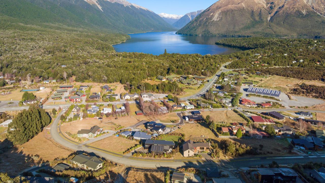
St Arnaud (Bayleys Real Estate)
CURIOUS NAME
Saint Arnaud is a small alpine village west of the St. Arnaud Mountain Range, 90 km (56 miles) south of Nelson and is situated at the northern end of Lake Rotoiti. It was settled during the gold rush of 1855 and named ‘New Bendigo’. The village was then named after the lake until 1921. The name St. Arnaud was gazetted on 19th of July 1951 by the Department of Lands and Survey to avoid confusion with a lake of the same name near Rotorua. Some local residents resisted the foreign name and still give their address as Lake Rotoiti.
Saint Arnaud, with a population of just 111, is part of the Nelson Lakes National Park. Catering for a small number of tramping and skiing tourists, the centre of the village has a store, a petrol station, a cafe-restaurant, camping facilities, a couple of small motels, chalets and accommodation for trampers. This lakeside settlement offers recreational activities like fishing, hunting, kayaking, small boat sailing, and gliding. In winter, snow sports take place primarily at Rainbow Skifield, a 60 minute drive from the village on the eastern side of the Saint Arnaud Range. I visited this out-of-the-way lakeside village when I did a trip from Nelson to Christchurch using the alternative to the main highway and I must admit, St Arnaud had little impact on me as I can’t remember anything about the place apart from the exotic (for New Zealand) name. Even the lake left no impact but I guess if you are wanting to get away from it all, St Arnaud would appeal.
NELSON LAKES NATIONAL PARK
Established in 1956, Nelson Lakes National Park covers 102,000 hectares of the northern most Southern Alps. The alpine lakes of Rotoroa and Rotoiti form the heart of this park. Both are surrounded by gently rising mountains with native honeydew beech forests growing right to the edges of the lakes which feed a variety of tuneful nectar-eating native birds. Apart from these two lakes another fourteen are located in this National Park. One of these is the Blue Lake which has been officially named the clearest lake in the world, and is located deep within the native forests of the national park (I have written an earlier blog on this lake.)
One attraction that does bring a modest number of people to the village is the strenuous 80 km (49 miles) Travers – Sabine tramping circuit. This 5 day tramp on rough tracks is for experienced hikers and follows the valley of the Travers River leading up over the sub-alpine Travers Saddle and then descends the Sabine River valley to Lake Rotoroa. From here walkers can complete the circuit back to Saint Arnaud by either crossing a low saddle to the valley of Lake Rotoiti or by using a higher route via Mount Angelus. If they feel too buggered, trampers can take a water taxi from the Sabine Hut on Lake Rotoroa back to St. Arnaud.
LAKE ROTOITI
Lake Rotoiti is a substantial mountain lake and is 82 metres (269 ft) deep with the water being fed by the Travers River. This narrow river is unsuitable for boats due to the many rocky cascades along its length. Water from the lake feeds the Buller River which flows for 177 km (110 mi) through the Buller Gorge to the Tasman Sea near the town of Westport.
The first European to see the lake was John Sylvanus Cotterell on 18th of January 1843. English explorers Thomas Brunner and Charles Heaphy reached the lake in November 1843, and they named it ‘Lake Arthur’ after Captain Arthur Wakefield who served with the Royal Navy before joining his brother, Edward Gibbon Wakefield in founding Nelson, but the native name remained. For many years the lake formed part of Nelson landowner John Kerr’s Lake Station – including Mt Robert. Kerr, who introduced trout to the lake, drowned there with many believing his son Robert to be responsible. The lake and Mt Robert reverted to the crown after Robert’s mismanagement of the estate in the years following his father’s death.
New Zealand’s South Island is known around the world for its spectacular alpine resorts, all located on the shores of great lakes and backed by dramatic mountains. However, St Arnaud is unique in remaining a quiet village undisturbed by the activities and excitement available at the other southern lakeside towns.
Ceidrik Heward
Ceidrik Heward is an Amazon TOP SELLING AUTHOR and has lived and worked in 7 countries working as a TV cameraman, director and film tutor. For the past 17 years he has focused on writing and has been published in magazines and newspapers in Europe, USA, Asia and the Middle East.
His interests include photography, psychology and metaphysics. He loves to read and always has at least 3 books on the go. He has written 22 manuals/books and has just completed his 4th short novel. Ceidrik believes sharing information and stories is the best way to stimulate the imagination and enrich our lives.


 Visit Today : 166
 Total Visit : 1133343
Speak Your Mind